

GEO T8 – Edge computing
Edge computing performs on-device processing directly on the image and video streams generated by the device.
GEO T8 is an industrial-grade continuous photo-monitoring device developed by Avacam, designed for monitoring landslides, unstable slopes, infrastructure, and geologically critical areas.
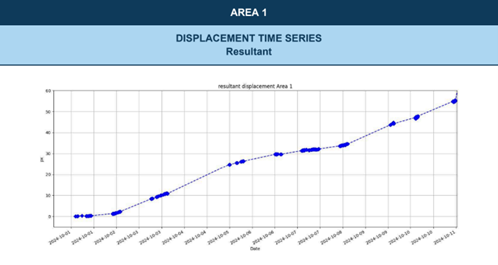
The system is based on multi-temporal analysis of high-resolution optical images, enabling the detection of even slow, millimeter-scale ground movements, which are crucial for risk prevention.
Photo monitoring: How it Works
At the core of the system is the photo monitoring technology, which combines:
- time-lapse images captured at regular intervals,
- advanced Digital Image Correlation (DIC) and Change Detection (CD) algorithms,
- automated analysis powered by artificial intelligence.
This approach makes it possible to:
- quantitatively measure surface displacements,
- generate deformation and displacement maps,
- identify terrain changes, collapses, and deformations over time.

Professional Imaging Quality
GEO T8 integrates an industrial 4K UHD imaging module:
- 1/2” Progressive Scan CMOS sensor
- Resolution: 3840 × 2160 (8MP – 4K)
- Motorized varifocal lens 2.8–12 mm
- Infrared night vision up to 50 m
- 120 dB WDR for high-contrast scenes
- IP67-certified housing, suitable for extreme environments.
A wide range of custom lenses up to 20 MP is available, allowing the system to be tailored to any monitoring distance or scale.
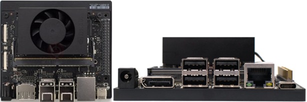
Edge Computing and Artificial Intelligence
The system can be equipped with an edge computing unit based on a fanless NVIDIA Jetson platform, enabling:
- on-device AI processing,
- local data buffering and analysis,
- continuous operation in remote or connectivity-limited environments.
Key features:
- CUDA-based AI acceleration
- NVMe/SSD local storage
- Operating temperature: –25°C to +65°C
Alert System and Continuous Control
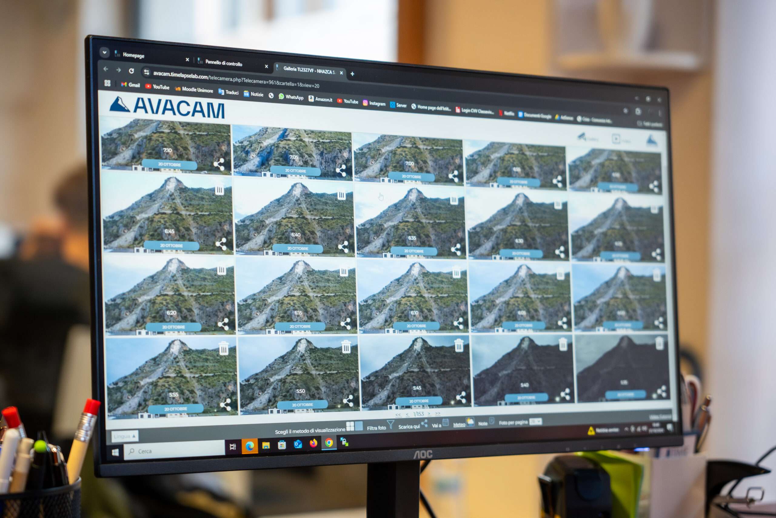
All GEO T8 devices are connected to the Avacam cloud platform, accessible 24/7:
- real-time image visualization,
- advanced image comparison modes (split, overlay, x-ray),
- full remote device management,
- automatic time-lapse video creation,
- periodic technical reporting.
The platform is entirely web-based, with role-based access control and complete remote operability.
Alert System and Continuous Control
GEO T8 includes an intelligent alert system that notifies users of:
- device malfunctions,
- power supply interruptions,
- significant weather events,
- relevant terrain variations.
Alerts are fully configurable and manageable remotely, ensuring maximum responsiveness and operational safety.
Privacy and GDPR Compliance
The platform integrates proprietary software based on neural networks (YOLOv4) for:
- automatic masking of faces, people, license plates, and vehicles,
- real-time image anonymization,
- full compliance with GDPR requirements.
The GEO T8 device is certified ISDP10003:2020 for the protection of personal data.

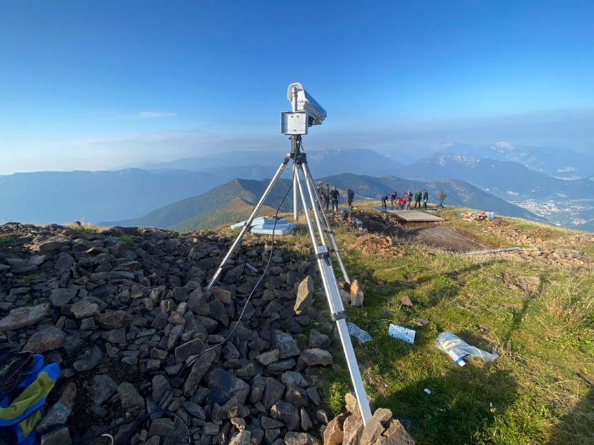
Industrial-Grade, Ready-to-Use Device
- Designed and manufactured entirely in Italy
- Industrial components (not consumer-grade hardware)
- Plug & Play installation
- No on-site maintenance required
- Continuous monitoring by the Avacam technical team
- IP67 enclosure, resistant to cold, rain, dust, and high-altitude conditions
- Third-party liability insurance included
Why Choose GEO T8
- Continuous and high-precision terrain monitoring
- Advanced AI-based data analysis
- Industrial reliability for long-term deployments
- Complete remote control and management
- Security, privacy, and regulatory compliance
- Scalable and fully customizable solution
AVACAM
TL8 GEO
Innovation
The TL8 GEO, an exclusive creation by Avacam, represents the pinnacle of image capture technology, offering unprecedented definition. Customisable to meet the needs of each customer, this system allows the selection of lenses suited to every specific requirement.
DOUBLE HEATER
The TL8 GEO device is equipped with a double heater that guarantees a constant internal temperature even in the most extreme weather conditions. This innovation allows us to maintain image clarity, preventing lens fogging and ensuring the reliability of our services in all weather conditions.
Robustness and Adaptability
Built to last, the TL8 GEO combines materials such as aluminium and steel, ensuring superior resistance to the elements and flexibility of installation, both on vertical and horizontal structures.
Versatile Energy Options
The TL8 GEO is available in different configurations to suit every need: from solutions that use a simple power supply to hybrid configurations with backup batteries, ensuring consistent performance in any scenario. It guarantees operational continuity both with a simple electrical connection and with autonomous battery solutions, to tackle any situation with confidence.
Advanced Software
The TL8 GEO device communicates with the software via a data SIM card. The software has been developed to process digital images and monitor movements and surface changes in the territory and structures. Using digital image correlation algorithms, it can detect minimal variations with millimetre-level precision, providing real-time data analysis and enabling an immediate response to the variations detected.
High-Quality Safety and Accessories
Certified to ISDP 10003:2020 standards for data security and privacy, and resistant to water and dust, the system is complemented by a range of accessories designed to optimise the user experience.
AVACAM
AVACAM CHARACTERISTICS
ENHANCED RELIABILITY
Our device combines aluminium and steel, ensuring reliability in any environment. An ultra-durable case protects against bumps and weather and makes it resistant also in extreme weather conditions.
OPERATIONAL FLEXIBILITY
Our devices are available in multiple configurations to suit every need: from a simple electrical connection to stand-alone solutions with battery, ensuring business continuity in any situation.
INTEGRAL PROTECTION
Equipped with an internal cable routing system and anti-aging gaskets, it also includes a low-consumption heater, offering maximum protection and long-lasting performance.