Hydrogeological risk. It’s in every civil protection report, every municipal emergency plan, every geotechnical brief — and it’s one of those terms that a lot of people nod at without being entirely sure what it means. This guide is for those people. No jargon, no unnecessary complexity. Just a clear explanation of what it is, why it matters, and what you can actually do about it.
1. What hydrogeological risk actually means
Let’s start with the word itself. “Hydro” comes from water. “Geo” refers to the earth and terrain. Put them together and you get a term that describes the risk posed by the interaction between water and land — specifically, what happens when water accumulates in, on, or under the ground in ways that cause terrain to become unstable or overwhelmed.
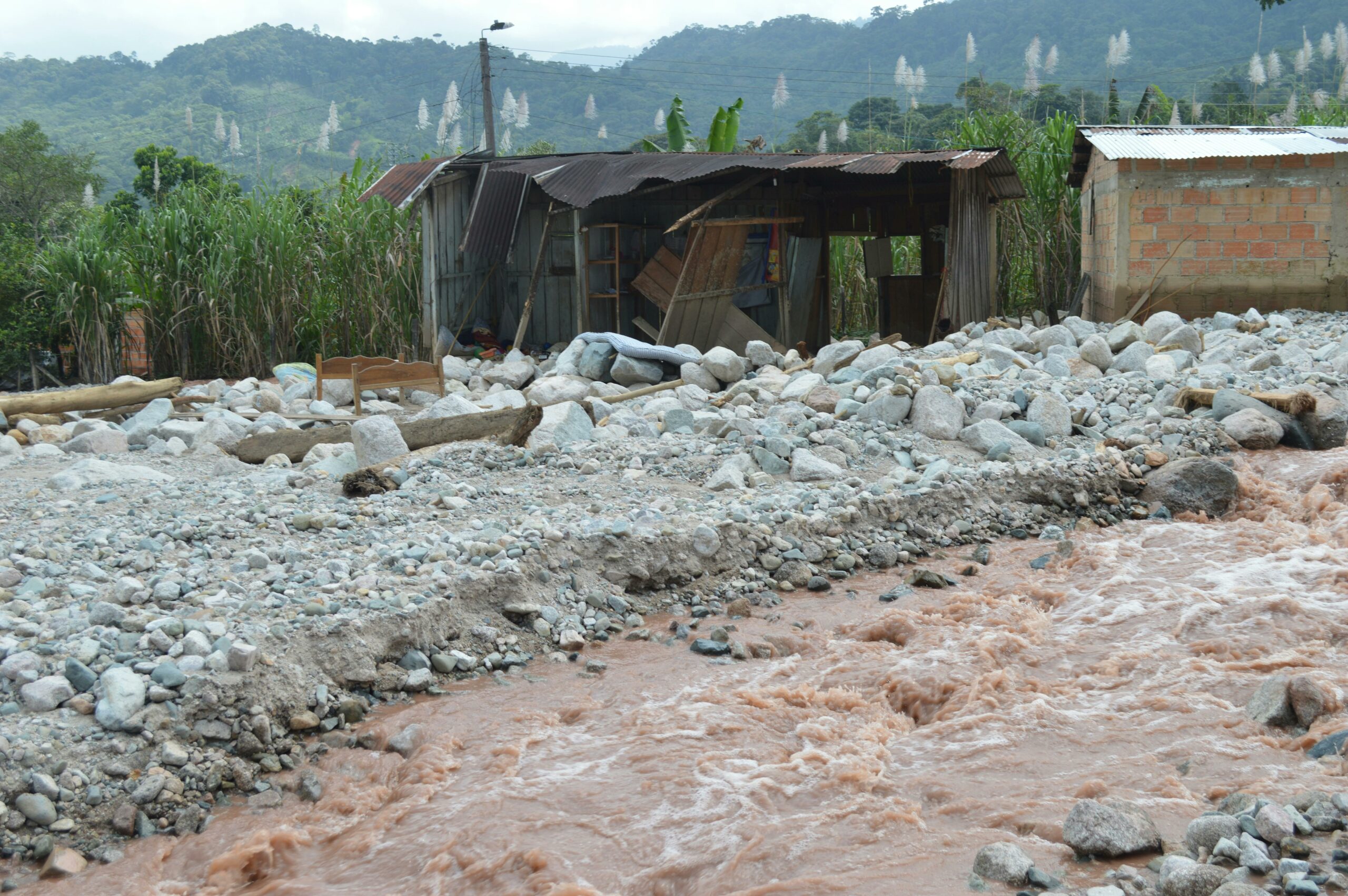
In practice, hydrogeological risk covers three main phenomena: landslides, floods, and erosion events. All three are driven, at least in part, by water moving through or across terrain in ways that exceed the ground’s capacity to absorb or resist it.
What makes this different from just “the risk of rain” is the combination of factors involved. A slope that handled heavy rainfall perfectly for a century might fail today because of changed vegetation cover, altered drainage patterns, increased urban development nearby, or — increasingly — more intense rainfall events driven by climate change. The terrain hasn’t necessarily changed. The conditions around it have.
Hydrogeological risk is the probability that a natural hazard involving water and terrain — a landslide, flood, or erosion event — will cause damage to people, infrastructure, or property in a specific area.
2. The risk formula — simplified
Geologists and civil protection authorities use a standard formula to calculate risk. It looks complicated on paper but the logic is straightforward once you break it down.
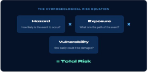
Hazard is about the terrain itself — how steep is the slope, what rock type is present, how much rainfall does the area receive, how saturated does the ground get. A steep clay slope in a high-rainfall Alpine valley has high hazard. A gentle granite hill in a dry region has low hazard.
Exposure is about what’s in the danger zone. An unstable slope above an empty forest has low exposure. The same slope above a national road, a railway line, or a village has very high exposure. Exposure increases every time someone builds something new in or near a risk area.
Vulnerability is about how much damage the hazard would cause if it hit the exposed elements. A modern reinforced building has lower vulnerability than an old stone farmhouse. A road with a diversion route has lower vulnerability than a single-access village road.
You can reduce risk by working on any of the three components. You can’t change the hazard much — geology is geology. But you can reduce exposure through land use planning, and you can reduce vulnerability through engineering works, early warning systems, and emergency procedures.
3. The three main types of hydrogeological risk
When authorities talk about hydrogeological risk, they’re typically referring to one or more of these three categories. They’re related — often the same rainfall event triggers more than one — but they behave differently and require different monitoring approaches.
-
Flood risk
The overflowing of watercourses, rivers, or drainage systems beyond their banks. Includes flash floods from intense rainfall, slow-onset river flooding, and coastal flooding. Affects flat and low-lying areas that landslides don’t — but the two often occur together in storm events.
-
Glacier & snowmelt risk
As glaciers retreat and permafrost thaws, previously stable terrain becomes unstable. Glacial lake outburst floods (GLOFs) can release millions of cubic metres of water with very little warning. A growing risk as climate change accelerates ice loss across Alpine and mountain regions globally.
In Italy, landslide risk is the dominant concern — the country has one of the highest landslide densities in Europe due to its geology, topography, and climate. But flood events cause the most widespread economic damage, and glacial risk is growing year on year as Alpine ice volumes decline.
4. Risk levels: what they mean in practice
Most European civil protection systems classify hydrogeological risk into four levels. The classifications affect what planning restrictions apply, what monitoring is required, and what response protocols must be in place. Here’s what those levels actually mean for the people who have to act on them.
| Level | Classification | What it means | Typical response |
|---|---|---|---|
| R4 | Very High | Possible loss of life, serious injury, destruction of buildings and infrastructure | Immediate intervention required. May require evacuation or permanent restriction of use |
| R3 | High | Possible injury to people, significant damage to buildings, disruption to infrastructure | Monitoring mandatory. Engineering works or operational restrictions likely required |
| R2 | Medium | Limited damage to buildings, low risk to people, possible disruption to activities | Monitoring recommended. Land use planning restrictions apply |
| R1 | Moderate | Marginal damage, negligible risk to people under normal conditions | Awareness and planning. No immediate action required |
5. Who is responsible for managing It?
This is where a lot of confusion arises — and where a lot of legal liability sits. Hydrogeological risk management in most European countries involves multiple overlapping layers of responsibility, and the boundaries between them are not always clear.
- National Government = Sets national risk maps, funds major interventions, coordinates civil protection framework and emergency response at national level.
- Regional Authorities = Produce regional hydrogeological risk plans (PAI in Italy), regulate land use in risk zones, fund monitoring programmes
- Municipalities = Responsible for local emergency plans, public road maintenance, informing citizens, and coordinating local response. Mayors carry direct legal responsibility in Italian law.
- Infrastructure Operators = Road and railway authorities, utility operators, and dam owners are responsible for monitoring and managing risk on their own assets.
- Private Landowners = In many jurisdictions, private landowners carry responsibility for managing risk on their own land — including slopes adjacent to public roads.
- Engineers & Consultants = Professional responsibility for risk assessment quality, monitoring system design, and the technical recommendations they provide to authorities
“The mayor is not a geologist. But in Italian law, the mayor is responsible for protecting citizens from foreseeable natural hazards — which means they need to know what risks exist and have systems in place to respond to them.”
6. How monitoring fits Into risk management
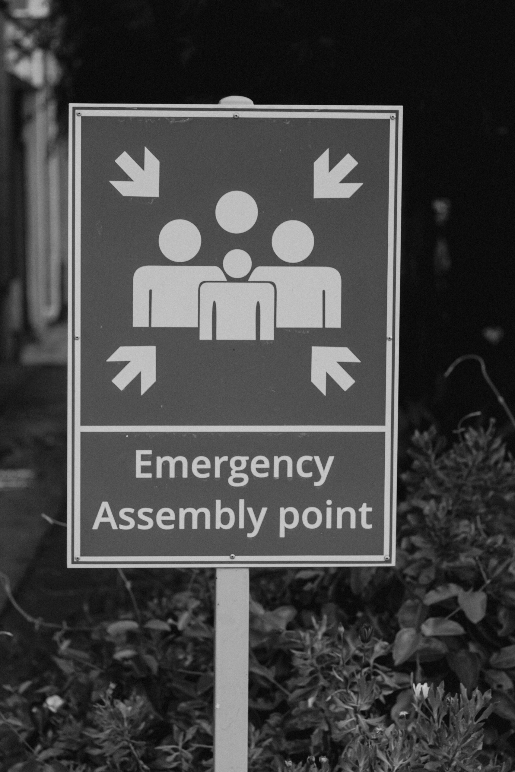
Understanding that a risk exists is step one. Doing something about it is step two. And for most hydrogeological risks — especially landslides and flood events — the most practical and cost-effective intervention available is continuous monitoring combined with an early warning system.
You can’t eliminate a landslide hazard by monitoring it. The geology doesn’t change. But monitoring gives you the one thing that makes the difference between a disaster and a controlled event: time.
A slope that is being continuously monitored with a system that alerts when displacement exceeds a threshold gives the people responsible enough lead time to inspect, assess, close a road, evacuate a building, or mobilise emergency resources. A slope with no monitoring gives them nothing — until it’s already moving fast enough to see with the naked eye, which is usually too late.
- Baseline documentation = Establish what “normal” looks like — image archive, displacement reference points, seasonal variation patterns. This is what all future comparisons are measured against.
- Continuous data capture = Regular high-resolution images transmitted to a cloud platform. Every 30 minutes in sensitive periods, hourly or daily for lower-risk ongoing surveillance.
- AI-driven anomaly detection = Automated comparison of each new image against the baseline. When displacement or change exceeds the defined threshold, an alert fires — before any human needs to review the images manually.
- Tiered alert protocol = Different alert levels trigger different responses — from a notification email at 3mm displacement, to a mandatory site inspection at 8mm, to road closure at 15mm. The thresholds are set before anything happens, so there’s no debate when an alert fires.
- Permanent archive for post-event analysis = Every image is stored permanently. After an event — whether a failure, a near-miss, or a legal dispute — the full documented history is available immediately.
7. Italy’s hydrogeological risk: the numbers
For context on why this matters so much in the Italian and broader European context, a few numbers are worth knowing. Italy is one of the most hydrogeologically at-risk countries in Europe — not because of bad luck, but because of the combination of its geology, topography, climate, and centuries of human settlement in risk-prone areas.
- Approximately 7.5 million people live in areas classified as high or very high landslide risk in Italy
- Around 94% of Italian municipalities contain areas at risk from landslide or flood events
- Italy records an average of over 500 significant landslide events per year, with major spikes following intense rainfall periods
- The economic cost of hydrogeological damage in Italy averages €3–4 billion per year — and that’s a normal year, not a major disaster year
- Despite this, a significant proportion of at-risk slopes, riverbanks, and flood zones remain unmonitored — relying on periodic inspections that may happen once a year or less
8. What you can actually do about it
If you’re an engineer, a municipal administrator, or an infrastructure operator reading this, here’s the practical takeaway — the things that are actually in your control.
-
Know your risk classification
Start with your regional hydrogeological risk plan. In Italy, this is the PAI (Piano di Assetto Idrogeologico), produced by each river basin authority. It maps risk zones and classifications for your area. If you manage roads, buildings, or infrastructure, you should know which of your assets sit in R3 or R4 zones.
-
Don’t rely only on annual inspections
A visual inspection once a year tells you what the slope looked like on one specific day. It tells you nothing about what happened between visits. The 4mm displacement that preceded a road closure last autumn started building weeks before the slope became visible dangerous. Annual inspections would have missed it entirely.
-
Set up monitoring before something goes wrong
This sounds obvious. It isn’t — most monitoring systems get installed after a near-miss or a first failure, not before. The cost difference between installing monitoring on a calm day and installing it as an emergency response is significant. More importantly, the baseline data that makes monitoring useful takes time to build. You can’t compress six weeks of reference images into one day of emergency installation.
-
Have a response protocol ready
A monitoring system that sends an alert with no pre-agreed response protocol is only marginally better than no monitoring at all. Before you install anything, agree with your team — and with the authorities who share responsibility — exactly what happens at each alert level. Who gets notified? Who makes the decision to close a road? What’s the threshold for calling the geotechnical consultant? Write it down. Sign it off. Then install the system.
-
Keep the data
Every image, every alert, every inspection note is potentially useful later — for insurance claims, for legal defence, for remediation design, and for understanding what happened if something goes wrong. Permanent cloud archiving is not a luxury. It’s the difference between having evidence and not having it.
9. The bottom line
Hydrogeological risk is not a niche technical topic for geologists. It’s the reason roads get closed, buildings get evacuated, and municipalities face legal consequences when things go wrong. Understanding what it is — and more importantly, what can be done about it — is a basic requirement for anyone who manages infrastructure, public safety, or land in a risk-prone area. The good news is that the tools to manage it effectively have never been more accessible, more affordable, or easier to deploy. The gap between knowing a risk exists and actually monitoring it has never been smaller. Closing that gap is a choice.
Have a site that needs monitoring?
Tell us about your risk zone. We’ll recommend the right device, help you set alert thresholds, and have it transmitting data within days.